Satellite images, drone photos, and even Google Earth could help identify communities most at risk for schistosomiasis, one of the world’s worst tropical diseases, researchers report.
A new study shows that clues in the environment can help identify transmission hotspots for the parasitic disease that is second only to malaria in its global health impact. Researchers used rigorous field sampling and aerial images to precisely map communities that are at greatest risk.
“This is a game-changer for developing-country public health agencies, because it will make it possible for them to efficiently find the villages that need their help the most,” says Chelsea Wood, an assistant professor in the University of Washington School of Aquatic and Fishery Sciences and lead author of the paper, published in PNAS.

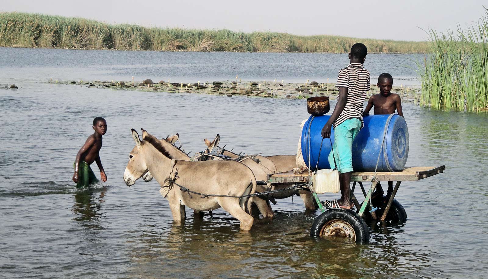
that can be seen in aerial images. In this photo, the dark, patchy vegetation in the water is the
ideal habitat for snails. (Credit: Andrew Chamberlin/Stanford)
More than 200 million people have schistosomiasis, which is treatable but has been difficult to eliminate from some regions of the world.
Schistosomes, the worms that cause the disease, grow within freshwater snails, where they multiply and enter the waters of rivers, lakes, and streams. To infect people, the worms penetrate the skin when they swim, bathe, or wade.
Schistosomiasis causes bloody urine and stool and abdominal pain, and can damage the liver, spleen, intestines, lungs, and bladder. In children, the infection can stunt growth and impair cognitive development.
The disease is found across sub-Saharan Africa, in South America, the Caribbean, the Middle East, and East and Southeast Asia. Though schistosomiasis is treatable with the drug praziquantel, it’s easy for a person to become re-infected after treatment if they swim or bathe in freshwater where the parasite is present.

May 2016. (Credit: Chelsea Wood/U. Washington)
Count the snails
The World Health Organization recently recognized that efforts to slow transmission of the disease through drug distribution weren’t working in some regions. In addition to drug distribution, WHO now recommends targeting the types of snails that transmit the parasitic worms, which is how this research team got involved.
“The ecological side of the problem is what’s holding us back from schistosomiasis control and elimination—and now ecologists are stepping in and filling that gap,” Wood says. “It’s an exciting time because there’s so much for us to learn. The kind of innovation we have introduced is just the beginning of what ecologists have to contribute to the control of schistosomiasis.”
The researchers worked across more than 30 sites in northwestern Senegal, where villages use a local river and lake for everything from bathing and swimming to washing dishes and clothes. This location was the epicenter of the largest schistosomiasis outbreak ever recorded, in the mid-1980s.

Kheune, Senegal. (Credit: Chelsea Wood/U. Washington)
The researchers first set out to methodically count and map the distribution of snails across each site over two years. The fieldwork was difficult and exhausting—they couldn’t let the schistosome-infested water touch their skin while they waded chest-deep to sample mud and plants. It was hot and humid, and the thick shoreline vegetation was full of mosquitoes, spiders, snakes—and even feral dogs.
They found snails in the river in patchy and inconsistent distributions over time. Snails might be present in one location, then completely absent three months later. Given the snails’ ephemeral nature, the researchers realized that targeting aggregations of snails for removal might not be an efficient way to reduce schistosomiasis transmission.

A better way to find schistosomiasis
Instead, they shifted their focus to the habitat where snails live. The snails thrive in unrooted, floating vegetation that is visible in images from satellites and drones.
Considering these habitat features, plus other data they had gathered about each site such as snail density, village size, and location, they used models to evaluate which factors could best predict schistosomiasis transmission. The total area of a water access point and the area of floating vegetation were the two best indicators that human infection would occur nearby.
These habitat features are all easy to measure in satellite or drone imagery.
“Counting snails is not an easy undertaking, and it also produces data that are not as useful as the data you can get from a drone,” Wood says. “Once we understand the association between snail presence and particular habitat features, we can use drone and satellite imagery to detect those habitat features. This cuts the time needed to evaluate the risk of schistosomiasis infection down to a fraction of what it would be if you were just looking at snails.”

infection in St. Louis, Senegal, May 2015.
(Credit: Chelsea Wood/U. Washington)
Public health agencies in Senegal can now look at aerial images across their jurisdiction, find areas with the most floating vegetation in water access points, and target those villages for schistosomiasis treatment, the researchers say.
“Now we can take these aerial images season to season and have an idea of how the pathogenic landscape changes in time and space. This can give us a better idea of infection rates,” says coauthor Giulio De Leo, a biology professor at Stanford University.
Can machine learning help?
The team is also trying to use machine learning to automate the identification of floating vegetation in photos, making it even easier for agencies to use the information. They plan to test their approach in other parts of Africa at a broader scale, using publicly available infection data and satellite imagery.
“We’re cautiously optimistic, but we still have some work to do to generalize our findings to new contexts,” says coauthor Susanne Sokolow, a research scientist at Stanford University.
“If, indeed, we find that the predictors for schistosomiasis are scalable and automatable, then we will have a powerful new tool in the fight against the disease, and one that fills a critical capacity gap: a way to efficiently target environmental interventions alongside human treatment to combat the disease.”
Additional coauthors are from Stanford University; the Royal Belgian Institute of Natural Sciences; Virginia Tech; the University of Washington; the University of North Carolina Wilmington; the University of California, Los Angeles; Notre Dame, London’s Natural History Museum; the University of London; and the Biomedical Research Center EPLS in Saint Louis, Senegal.
The University of Michigan, the Alfred P. Sloan Foundation, the Wellcome Trust, the Bill and Melinda Gates Foundation, Stanford University, the National Institutes of Health, and the National Science Foundation funded the work.
Source: University of Washington